Day 7:
I'm heading back to Reno today to catch my flight. Can't take a hike because I need to leave by 10am to safely make it. So it was just a lazy morning and long drive.
The one cool thing was while passing one of many ranches/farms, I saw a coyote running thru a herd of cattle. Maybe he was looking for some veal.
It was a great trip; there are more pictures posted at: http://www.flickr.com/photos/whalerider33/sets/72157634811281238/
Friday, July 26, 2013
July 19: Mono Pass
Day 6: I'm heading back to Mosquito Flats to hike up to Mono Pass at 12000 ft. Start on the same trail from the other day's Little Lakes hike but veer off about 1/4-1/2 mile (once through the walk thru the flowers and along the stream).
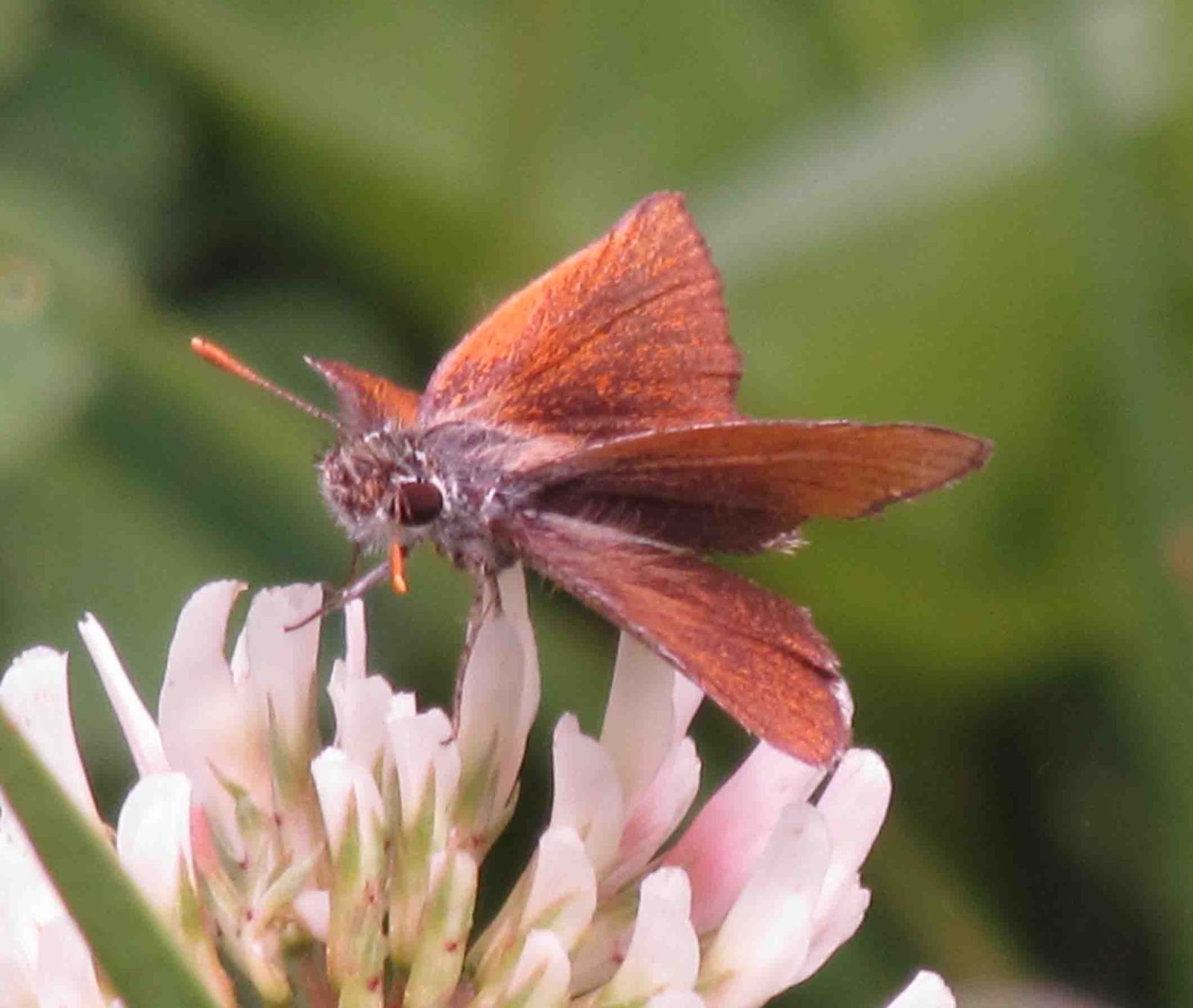
Heading here because I just want to get to 12K but also there's a bfly (Sierra Skipper) that is endemic to this area and flies above 11,500ft. My "bfly guy" gave me 2 locations, one in which he's actually been and seen them (down around the Bristlecone Pine area) and the 2nd was this pass -- and he's never been here so if I see one, I can give him details.
It's a little warmer today when I start (around 65degrees). Seems cool but maybe its my imagination but its really warm with the sun intensity at 10K+. The trail is about 4 miles (one-way) with an elevation of 2000ft. From what I've read, its only a 7% grade for the 1st 1.8 miles and 12% the rest (of course that's just an average).
The trail starts up right from the start. Long switchbacks. Some flat and dirt trail; other parts rocky steps. The views of the Little Lakes Valley get better with every completion of a switchback as I'm just getting higher up.

I can now see why Heart Lake is named accordingly.
Lots of flowers and bflys. I see a Little Elephant head (the smaller version of Elephant Head - still has the ears and the trunk - though I think the other Elephant head looks more like an elephant.)

Part way to Ruby Lake I come across a little pond (its a brackish pond) and looking across is one of the beautiful mt peaks of the Little Lakes Valley.
 I continue to climb, the slopes getting rockier and tougher looking. And I'm hot and not sure if I'm making to the top today. (I also have a very sore/bruise little toe -- hate when furniture jumps out in front of you -- so walking isn't pain-free.)
I come across another wet "pond" and there's a dark creature in the middle of the water. I'm pretty excited because I don't know what this thing is - but its sure having fun in the water. Well, I get up a little closer and realize that its just a black dog -- actually a dog that passed me on its way up. He's actually chasing fish -- its pretty funny. His owners finally make it down the trail. Older couple (local) and we talk for a bit. He tells me not to bother with Mono Pass ("it's just big rocks", "do it only if you want the exercise"). He suggested I just go to Ruby Lake -- it's the jewel of the hike. Well at this point, I'm convinced -- Mono Pass is for another day (and I need to get here around 7am instead).
The turnoff for Ruby Lake is about 100yrds up the trail. The trail follows a stream (which flows into the little pond the dog was playing in). I follow the trail and I can see the big mountains that I'm coming closer to with every step.
The trail opens up into a flatter area where the water pools - not at the lake yet but it still looks pretty.

A little further up the trail I come to the lake pressed up against the granite walls of the mountains (approx. 11141ft). I love these mountain lakes because they are so clear.
 I can only investigate the one side as there is no trail around it because of the mts. I find where the point of the lake where the stream starts and take a little rest.

Then its all downhill. Boy is it hot -- I'm glad I didn't try to make it to Mono Pass today.
In Mammoth Lakes, there's a European Bakery that I eyed last year and everyday this week. I decide to stop after supper. Some wonderful looking desserts; the Baclava caught my eye. Haven't had a slice in years...until tonight. Hmmmmmm!
Heading here because I just want to get to 12K but also there's a bfly (Sierra Skipper) that is endemic to this area and flies above 11,500ft. My "bfly guy" gave me 2 locations, one in which he's actually been and seen them (down around the Bristlecone Pine area) and the 2nd was this pass -- and he's never been here so if I see one, I can give him details.
It's a little warmer today when I start (around 65degrees). Seems cool but maybe its my imagination but its really warm with the sun intensity at 10K+. The trail is about 4 miles (one-way) with an elevation of 2000ft. From what I've read, its only a 7% grade for the 1st 1.8 miles and 12% the rest (of course that's just an average).
The trail starts up right from the start. Long switchbacks. Some flat and dirt trail; other parts rocky steps. The views of the Little Lakes Valley get better with every completion of a switchback as I'm just getting higher up.
I can now see why Heart Lake is named accordingly.
Lots of flowers and bflys. I see a Little Elephant head (the smaller version of Elephant Head - still has the ears and the trunk - though I think the other Elephant head looks more like an elephant.)
Part way to Ruby Lake I come across a little pond (its a brackish pond) and looking across is one of the beautiful mt peaks of the Little Lakes Valley.
I come across another wet "pond" and there's a dark creature in the middle of the water. I'm pretty excited because I don't know what this thing is - but its sure having fun in the water. Well, I get up a little closer and realize that its just a black dog -- actually a dog that passed me on its way up. He's actually chasing fish -- its pretty funny. His owners finally make it down the trail. Older couple (local) and we talk for a bit. He tells me not to bother with Mono Pass ("it's just big rocks", "do it only if you want the exercise"). He suggested I just go to Ruby Lake -- it's the jewel of the hike. Well at this point, I'm convinced -- Mono Pass is for another day (and I need to get here around 7am instead).
The turnoff for Ruby Lake is about 100yrds up the trail. The trail follows a stream (which flows into the little pond the dog was playing in). I follow the trail and I can see the big mountains that I'm coming closer to with every step.
The trail opens up into a flatter area where the water pools - not at the lake yet but it still looks pretty.
A little further up the trail I come to the lake pressed up against the granite walls of the mountains (approx. 11141ft). I love these mountain lakes because they are so clear.
Then its all downhill. Boy is it hot -- I'm glad I didn't try to make it to Mono Pass today.
In Mammoth Lakes, there's a European Bakery that I eyed last year and everyday this week. I decide to stop after supper. Some wonderful looking desserts; the Baclava caught my eye. Haven't had a slice in years...until tonight. Hmmmmmm!
Wednesday, July 24, 2013
July 18: Bishop (and Butterflies)
Day 5: A non-hiking (rest) day as its time to hopefully find the Alkali Skipper. This bfly flies near alkaline saltgrass flats in deserts (and it has a pretty small range because of the required habitat - parts of western NV and small section of CA). I have a good tip (by the same bfly author) that there's a good chance I'll see them about 5miles north of the city of Bishop. Keeping my fingers cross on the 30-40 minute drive down.
The road I turn on is a gravel road and its pretty brown, dry and barren but my instructions say to go a couple hundred yards and sure enough, I'm back in the green again. There's a little road going south with a truck parked and an official looking guy around. I drive past simply because I want to make sure I'm in the right area and when it turns brown, dry and barren in another 100 yrds or so, I knew I past the spot.
But before I turn around, I take a quick walk at the far end of the green. Nothing but me, saltbrush plants and cow pies. I'm looking for a white heliotrope (an alkali plant) - which I can't find here. So back in the car and up the road a bit. (Oh, I did manage to scare up a jackrabbit.)
I stop near the side road and the guy promptly comes up and wonders what I'm doing there -- told him I'm here looking for a bfly. Which he was OK with as he was with CA water and power and he (and some others were doing a plant survey --- don't think this area will take long :))
Right outside my car were a bunch of Melissa blues -- beautiful blue with a bright orange outline. And they were everywhere!
 Well I wandered around for about an hour trying to kick up a skipper; wandered back and forth looking at the heliotrope and finally, there it was almost at my feet and orange Alkali Skipper (yea!).

I managed to get 2 photos and he was gone in a blink of an eye. Probably the fastest bfly I've seen.
I wandered around for another 1/2 hour or so, saw a couple of Western Pygmy Blue - the smallest bfly in the States w/ about a 1/2in wingspan) and a monarch. Time to leave as its getting very hot!
 Its still earlier but too late to take a hike, I think I'm going to try and see a bit of Yosemite.
On my way back north on 395 -- its a 4 lane divided hwy that is surrounded by sagebrush - a coyote decides he's going to trot across the northbound lanes, I had to slam on my brakes to avoid hitting him. Must be hungry for lunch as its about noon. He just looked at me and continued across -- hope he made it across the SB lanes.
Well I about get to the Yosemite gate but there's a long line of people, so I decide to turn around and stop at a Nature Trail just a little bit down the road. The parking area is empty. So off I go. Its a little 1/4 mile trail; its has nice signs describing the habitat etc. There's a little wet meadow off the trail so I decide to investigate it for bflys. There were Edith Coppers, Clodius Parnassians (black antenna), Ruddy Coppers, Sierra Blues, Mexican Cloudywings and a Mariposa Copper (lifer!!!).
 The trail continued around a lake and back to the parking lot. A fine little stop and the end of my day.
Worked out just fine!!
The road I turn on is a gravel road and its pretty brown, dry and barren but my instructions say to go a couple hundred yards and sure enough, I'm back in the green again. There's a little road going south with a truck parked and an official looking guy around. I drive past simply because I want to make sure I'm in the right area and when it turns brown, dry and barren in another 100 yrds or so, I knew I past the spot.
But before I turn around, I take a quick walk at the far end of the green. Nothing but me, saltbrush plants and cow pies. I'm looking for a white heliotrope (an alkali plant) - which I can't find here. So back in the car and up the road a bit. (Oh, I did manage to scare up a jackrabbit.)
I stop near the side road and the guy promptly comes up and wonders what I'm doing there -- told him I'm here looking for a bfly. Which he was OK with as he was with CA water and power and he (and some others were doing a plant survey --- don't think this area will take long :))
Right outside my car were a bunch of Melissa blues -- beautiful blue with a bright orange outline. And they were everywhere!
I managed to get 2 photos and he was gone in a blink of an eye. Probably the fastest bfly I've seen.
I wandered around for another 1/2 hour or so, saw a couple of Western Pygmy Blue - the smallest bfly in the States w/ about a 1/2in wingspan) and a monarch. Time to leave as its getting very hot!
On my way back north on 395 -- its a 4 lane divided hwy that is surrounded by sagebrush - a coyote decides he's going to trot across the northbound lanes, I had to slam on my brakes to avoid hitting him. Must be hungry for lunch as its about noon. He just looked at me and continued across -- hope he made it across the SB lanes.
Well I about get to the Yosemite gate but there's a long line of people, so I decide to turn around and stop at a Nature Trail just a little bit down the road. The parking area is empty. So off I go. Its a little 1/4 mile trail; its has nice signs describing the habitat etc. There's a little wet meadow off the trail so I decide to investigate it for bflys. There were Edith Coppers, Clodius Parnassians (black antenna), Ruddy Coppers, Sierra Blues, Mexican Cloudywings and a Mariposa Copper (lifer!!!).
Worked out just fine!!
Tuesday, July 23, 2013
July 17: Saddlebag Lake (yes, again)
Day 4: Had to go back and find that Heather Blue. The skies are clear today so my hopes are high. I'm also planning to find Secret Lake; its around 11,000 ft but if off-trail -- I'm just not sure how obscure it is.
I get to the lake around 8am. Decide to take the water taxi today and I'm the only tourist on the boat (w/ 2 employees). One guy asks where I was going - Secret Lake - and he sat down and told me how to get there (and that the only real trail was to follow a stream up). He also told/showed me how to follow a ridge to get up to a crest from which I can peer down into Yosemite. Sounds pretty cool.
I get off the boat and I pretty much have the whole place to myself. North Peak (and the surrounding mts) look better in the sun -- and so do their reflections in the lakes.

Many more butterflies out today - go figure, its sunny out. But I head directly for the southern edge of Steelhead Lake. There's an official trail (probably made by fishermen) that veers off that heads to its southwest corner. I'm actually excited because there's a waterfall (small one) on the west side of the lake and I can finally (hopefully) get close to it. (I'm getting a sideview from this trail.)
The trail stops at some rocks. There are monkeyflower and white heather -- I'm looking for the Heather Blue but see nothing. Had to do some scrambling up the rocks and at the top was greeted by a wonderful view of Cascade Lake (and many other unnamed lakes/waterholes) and an awesome views of North Peak and the mountains.
I see a large grey ground squirrel??? with a long tail. He's sounding the alarm as I approach.
 The reflections are just amazing back here.
It's very tricky moving around because its either a dead end into water, a cliff or higher rocks. So I'm up/down, backtracking, weaving all around. I finally find a way to a creek -- the creek that is the waterfall and I cross at the source of the creek.
 I make my way down next to the waterfall. Much better up close than from across the lake.
Well, I decide that it may be a little too rugged for me to go Secret Lake. It's off trail and if I twist and ankle, I'm in a bit of a pickle.
 So I continue down the west side of the lake and head up to a ridge (which I was on last year) that will take me above Steelhead Lake back to the actual loop trail where I will finish out the rest of the 5 mile loop.
I guess I should mention that the Saddlebag Lake hike also has plenty of lakes (along the loop, I'll pass Greenstone, Wasco, Potter, Cascade, Steelhead, Excelsior, Shamrock, Helen, Odell, and Hummingbird). The west side, in my opinion, is the prettiest with the mountain backdrop. The east side is drier and rockier.
Anyway, I'm back on the trail and heading toward Helen Lake (past Excelsior and Shamrock). This part of the trail is a bit more rugged as it crosses rockside areas, has a cliff you have to make your way down (tricky but at least there are some cairns this year to help -- unfortunately, there was a misplaced one that I followed and ended up at a steep drop-off -- helpless feeling cause I can see the trail below but I'm not getting there from where I'm at ....alive. But there's a couple coming up and they point me in the right direction.)
Even with the rockiness, there are patches of grass and flowers.
There's a bit of snow on part of the trail on the way down to Helen Lake but that's easily skirted. Helen lake is a bit strange (too me anyway) as it sits in a bowl -- coming from the west I have to go down to get to it but to get around it I have to climb a rocky/scree snow chute.
But the lake is beautiful and it still has views of North Peak.
 Coming around the north side is tricky. I remember this from last year when there was people jammed up to get down a cliff and over the creek. No people this year -- only fishermen and they were down by the lake - but still tricky. I see the cairn and see only a steep cliff; I see a side trail and head down. There are rocks in the water that I could hop across but most a bit underwater (not the best option) and the way to the log (to cross the stream) had a rock wall/water in the way. So I went back up for another look --- I still see no easy way down. So back down I go, I find some small rocks just above the water that perhaps if I hug the rock wall I can make it around to the log. And it works!!! And I still have dry feet! I look up and now I see the way down -- it was to the right of the cairn not the left (oh well, store that away for another day).
The trail is now all rocky as it follows the lake down the east side. There are white columbine along the way. I meet one of the fishermen --- he's with his buddies who were now all around the lake. Said they were at the Conness Lakes below the Conness Glacier the other day and recommended it to me -- still part of the Saddlebag Lake area. Maybe next year.
I continue to the snow chute to get my way up and out of here. There's more snow off the trail as I start up the chute and there's a big glob of snow in the chute (thankfully off the trail).
 There's Rockslide Checkerspots in here! And there's water running down next to the trail (I don't remember that last year).
When I get past the snow, it gets a little grassier/flowery around the creek and I see a Parnassian and its landed on monkeyflower. Super-zoom time as I'm not heading back down. I find out later that this is a Sierra Nevada Parnassian -- and as per its name, only flies in the Sierra Nevada Mts above the treeline (lifer!!) [This bfly has white/black banded antenna where the Clodius which flies in the same region has black antenna.]

I finally make my way totally out the Helen Lake bowl.

And am heading to Odell Lake (the east side). I find another batch of white heather and I see a blue. But it flying and when it lands on a flower, the wind (its very windy) blows the flower around so its next to impossible to get a good look. I see what looks like a little rock on a bigger rock - it may be a bfly. But for some reason, instead of using my camera to take a look, I try to get closer -- and of course it flies :(
So I wait for one to land, and wait. Finally, one lands on the heather -- it has to be a Heather Blue!!!!
Success!! (Lifer!)
 As I continue around Odell Lake, it seems that the trail ends at a scramble up a steep (but short - 10ft) screen slope. I don't remember this and really don't want to climb up that especially since I'm already walking on a 3ft ledge. But its looks like the only way up so up I go. But the trail wasn't there. I look around and the trail is 20ft ahead of me -- it never ended, I just couldn't see it from trail below.
I find some shade above Odell Lake for a quick lunch.
Once I get around Odell, it opens up, less rocks but dry. There are lots of blues and Sierra Sulphers flying in the few wetter areas. (Actually have seen a lot of Sierra Sulphers today -- I think I saw 2 last year - probably 30+ today.)
Its still early so I go and try and find the white heather off the trail from Monday. Never found it. But did see Sierra Blues (yes, endemic to the Sierras)
Take the boat back across the lake and stop at the Saddlebag Resort for some of their famous pie (which I did have last year) -- Cherry today. Oh the joys of hiking, you can eat all this fine dessert!
I get to the lake around 8am. Decide to take the water taxi today and I'm the only tourist on the boat (w/ 2 employees). One guy asks where I was going - Secret Lake - and he sat down and told me how to get there (and that the only real trail was to follow a stream up). He also told/showed me how to follow a ridge to get up to a crest from which I can peer down into Yosemite. Sounds pretty cool.
I get off the boat and I pretty much have the whole place to myself. North Peak (and the surrounding mts) look better in the sun -- and so do their reflections in the lakes.
Many more butterflies out today - go figure, its sunny out. But I head directly for the southern edge of Steelhead Lake. There's an official trail (probably made by fishermen) that veers off that heads to its southwest corner. I'm actually excited because there's a waterfall (small one) on the west side of the lake and I can finally (hopefully) get close to it. (I'm getting a sideview from this trail.)
The trail stops at some rocks. There are monkeyflower and white heather -- I'm looking for the Heather Blue but see nothing. Had to do some scrambling up the rocks and at the top was greeted by a wonderful view of Cascade Lake (and many other unnamed lakes/waterholes) and an awesome views of North Peak and the mountains.
I see a large grey ground squirrel??? with a long tail. He's sounding the alarm as I approach.
It's very tricky moving around because its either a dead end into water, a cliff or higher rocks. So I'm up/down, backtracking, weaving all around. I finally find a way to a creek -- the creek that is the waterfall and I cross at the source of the creek.
Well, I decide that it may be a little too rugged for me to go Secret Lake. It's off trail and if I twist and ankle, I'm in a bit of a pickle.
I guess I should mention that the Saddlebag Lake hike also has plenty of lakes (along the loop, I'll pass Greenstone, Wasco, Potter, Cascade, Steelhead, Excelsior, Shamrock, Helen, Odell, and Hummingbird). The west side, in my opinion, is the prettiest with the mountain backdrop. The east side is drier and rockier.
Anyway, I'm back on the trail and heading toward Helen Lake (past Excelsior and Shamrock). This part of the trail is a bit more rugged as it crosses rockside areas, has a cliff you have to make your way down (tricky but at least there are some cairns this year to help -- unfortunately, there was a misplaced one that I followed and ended up at a steep drop-off -- helpless feeling cause I can see the trail below but I'm not getting there from where I'm at ....alive. But there's a couple coming up and they point me in the right direction.)
Even with the rockiness, there are patches of grass and flowers.
There's a bit of snow on part of the trail on the way down to Helen Lake but that's easily skirted. Helen lake is a bit strange (too me anyway) as it sits in a bowl -- coming from the west I have to go down to get to it but to get around it I have to climb a rocky/scree snow chute.
But the lake is beautiful and it still has views of North Peak.
The trail is now all rocky as it follows the lake down the east side. There are white columbine along the way. I meet one of the fishermen --- he's with his buddies who were now all around the lake. Said they were at the Conness Lakes below the Conness Glacier the other day and recommended it to me -- still part of the Saddlebag Lake area. Maybe next year.
I continue to the snow chute to get my way up and out of here. There's more snow off the trail as I start up the chute and there's a big glob of snow in the chute (thankfully off the trail).
When I get past the snow, it gets a little grassier/flowery around the creek and I see a Parnassian and its landed on monkeyflower. Super-zoom time as I'm not heading back down. I find out later that this is a Sierra Nevada Parnassian -- and as per its name, only flies in the Sierra Nevada Mts above the treeline (lifer!!) [This bfly has white/black banded antenna where the Clodius which flies in the same region has black antenna.]
I finally make my way totally out the Helen Lake bowl.
And am heading to Odell Lake (the east side). I find another batch of white heather and I see a blue. But it flying and when it lands on a flower, the wind (its very windy) blows the flower around so its next to impossible to get a good look. I see what looks like a little rock on a bigger rock - it may be a bfly. But for some reason, instead of using my camera to take a look, I try to get closer -- and of course it flies :(
So I wait for one to land, and wait. Finally, one lands on the heather -- it has to be a Heather Blue!!!!
Success!! (Lifer!)
I find some shade above Odell Lake for a quick lunch.
Once I get around Odell, it opens up, less rocks but dry. There are lots of blues and Sierra Sulphers flying in the few wetter areas. (Actually have seen a lot of Sierra Sulphers today -- I think I saw 2 last year - probably 30+ today.)
Its still early so I go and try and find the white heather off the trail from Monday. Never found it. But did see Sierra Blues (yes, endemic to the Sierras)
Take the boat back across the lake and stop at the Saddlebag Resort for some of their famous pie (which I did have last year) -- Cherry today. Oh the joys of hiking, you can eat all this fine dessert!
July 16: Little Lake Valley
Day 3: Today is sunny and I'm off to Little Lakes Valley. I was here last year and I'm so looking forward to today. Starting at10,200ft, this place is just heaven on Earth for me - a valley surrounded by mountains; filled with streams and lakes. Lakes named: Mack, Marsh, Heart, Box, Long, Chickenfoot (my favorite) and Gems Lake. There are usually temporary ponds and wet areas -- but this year they were pretty much dry already. With all the water, there are so many different flowers from the start to the end of the trail. And all this starts at a trailhead called Mosquito Flats. How can't it be just awesome!!
I get to the TH and its a cool 53degrees - just perfect hiking weather. The problem: there are a bunch of kids gathering for the same hike - mmmm, maybe not the quiet hike I'm envisioning. I stall to let them get a head start - and so they can all get done with the pit toilets :)
The trail from the parking lot climbs about 200ft alongside a stream and thru bunches of flowers. The group is over the first hill, so I start off. I catch the stragglers before the trail flattens out at the intersection where the Mono Pass veers off. Fortunately, the group was taking a break and I got around them (yea!) - though I'm pretty sure I'll meet up with them at some point today.
One last little hill and ... the valley.
 Feeling good today -- must be the cool temps -- and have a pretty good pace going, despite looking at flowers (allium, shooting stars, elephanthead, ranger buttons,
 columbine (white, red), paintbrush - some of these are very tiny and colored red/yellow, pink, etc.
I cross streams on conveniently placed rocks. And before I knew it I was at Long Lake (about 2miles). The trail follows the west side of Long Lake - sandwiched between a rocky mountain and the lake. There are tons of columbine against the mountains in the shade. As I walk down the lake I hear chirping and I hear wings fluttering -- 2 hummingbirds zipping around. They'd stop for just moments on the bushes and take off again -- never got a good look to even try to ID them.
I continue on towards Chickenfoot Lake. The grade gets steeper (which is why most folks stop at Long Lake) but its worth the climb (The 3.5 mile hike only goes up about 700ft so its not bad if you can manage the thin air.)
I get to the Chickenfoot turnoff (2.8miles) but my goal right now is to get to Morgan Pass. I'll visit the lake on the way back cause it was awesome last year. At around 3.4 miles I get to the junction of Morgan Pass and Gems Lake. It's Morgan Pass -- map says its about 0.3 miles and 200 ft -- pretty steep but at least the trail is wide and looks like an old road (though I wouldn't want to drive on it). Very rocky (little vegetation but there are some flowers here and there) but the views looking back on the valley are pretty nice.
I see a Parnassian fly by and off the side of the trail -- not chasing that one, not sure I'd survive the 1st step.
I get to the top -- 11,110 - highest I've ever walked. Nothing really exciting, just a bunch of very large grey rocks/boulders.
 I wanted to continue to Upper Morgan Lake but I couldn't remember how far it was and I couldn't see it, so back down and to Gems Lake. (Next time, I'll get there.)
Have to cross a creek to get here -- lots of monkeyflowers, daisies as well as paintbrush.

I figured Gems Lake might be crowded (perhaps with the kids) but when I got there, only one couple - I met them down at the hummingbirds. Found a nice cozy spot in the shade under a pine tree my feet dangling over the lake. I had lunch watching the trout swim around. (Gems Lake sits at about 10,900 feet nestled by mountains on 2 sides and is the perfect destination for a day hike.)

Time to visit Chickenfoot Lake -- last year there were so many little paintbrush around the lake it was amazing. This year I'm not sure what exactly happened. But the trail I was on led to a marsh (but other people were on the trail too) -- not sure if I took a side trail to the lake last year or perhaps the lake was really low but it was a little disappointing. (I'll just have to keep last year's images in my head.)
Back down the trail, lots of people coming up the trail now (I'm glad I'm heading the opposite direction). Finished about 2pm (around 9miles total). The whole way back I'm think "pie". Last year when I was here, I hiked Little Lakes and the next day met some folks who knew the hike and asked if I stopped for pie at the Rock Creek Lodge (supposed to be some great pie). Well, I didn't know about it then so now that I know....must stop.
I got to the lodge and they only had 2 pieces left -- Coconut Cream. Got one of those slices and if I had been a couple minutes later, I would've missed out. Mmmmmmmmm!!!!! What an ending to a great day!
I get to the TH and its a cool 53degrees - just perfect hiking weather. The problem: there are a bunch of kids gathering for the same hike - mmmm, maybe not the quiet hike I'm envisioning. I stall to let them get a head start - and so they can all get done with the pit toilets :)
The trail from the parking lot climbs about 200ft alongside a stream and thru bunches of flowers. The group is over the first hill, so I start off. I catch the stragglers before the trail flattens out at the intersection where the Mono Pass veers off. Fortunately, the group was taking a break and I got around them (yea!) - though I'm pretty sure I'll meet up with them at some point today.
One last little hill and ... the valley.
I cross streams on conveniently placed rocks. And before I knew it I was at Long Lake (about 2miles). The trail follows the west side of Long Lake - sandwiched between a rocky mountain and the lake. There are tons of columbine against the mountains in the shade. As I walk down the lake I hear chirping and I hear wings fluttering -- 2 hummingbirds zipping around. They'd stop for just moments on the bushes and take off again -- never got a good look to even try to ID them.
I continue on towards Chickenfoot Lake. The grade gets steeper (which is why most folks stop at Long Lake) but its worth the climb (The 3.5 mile hike only goes up about 700ft so its not bad if you can manage the thin air.)
I get to the Chickenfoot turnoff (2.8miles) but my goal right now is to get to Morgan Pass. I'll visit the lake on the way back cause it was awesome last year. At around 3.4 miles I get to the junction of Morgan Pass and Gems Lake. It's Morgan Pass -- map says its about 0.3 miles and 200 ft -- pretty steep but at least the trail is wide and looks like an old road (though I wouldn't want to drive on it). Very rocky (little vegetation but there are some flowers here and there) but the views looking back on the valley are pretty nice.
I see a Parnassian fly by and off the side of the trail -- not chasing that one, not sure I'd survive the 1st step.
I get to the top -- 11,110 - highest I've ever walked. Nothing really exciting, just a bunch of very large grey rocks/boulders.
Have to cross a creek to get here -- lots of monkeyflowers, daisies as well as paintbrush.
I figured Gems Lake might be crowded (perhaps with the kids) but when I got there, only one couple - I met them down at the hummingbirds. Found a nice cozy spot in the shade under a pine tree my feet dangling over the lake. I had lunch watching the trout swim around. (Gems Lake sits at about 10,900 feet nestled by mountains on 2 sides and is the perfect destination for a day hike.)
Time to visit Chickenfoot Lake -- last year there were so many little paintbrush around the lake it was amazing. This year I'm not sure what exactly happened. But the trail I was on led to a marsh (but other people were on the trail too) -- not sure if I took a side trail to the lake last year or perhaps the lake was really low but it was a little disappointing. (I'll just have to keep last year's images in my head.)
Back down the trail, lots of people coming up the trail now (I'm glad I'm heading the opposite direction). Finished about 2pm (around 9miles total). The whole way back I'm think "pie". Last year when I was here, I hiked Little Lakes and the next day met some folks who knew the hike and asked if I stopped for pie at the Rock Creek Lodge (supposed to be some great pie). Well, I didn't know about it then so now that I know....must stop.
I got to the lodge and they only had 2 pieces left -- Coconut Cream. Got one of those slices and if I had been a couple minutes later, I would've missed out. Mmmmmmmmm!!!!! What an ending to a great day!
Monday, July 22, 2013
July 15: Saddlebag Lakes
Day 2: heading to Saddlebag Lake. Its right outside the east entrance of Yosemite and at a little over 10,000 ft, it is so amazing that I just had to come back this year.
Last year, I took the water taxi across Saddlebag Lake instead of walking the trail on either the west or east side. (It saves 2-3 miles round trip, its worth it). But today, I'm in search of the Heather Blue butterfly. This butterfly has, not too long ago, been identified as its own species - no longer considered a Sierra Blue. It is endemic to a very small region of the high Sierras and the Saddlebag Lake area is in that region. My source, the author of my favorite butterfly guide and a man I've met on 2 bfly trips, said to walk the west lake trail and I should find them once I exit the rocks and into the meadow -- and to look around the white heather the butterfly's host plant (red heather grows here and is actually the more prevalent species). (And too look for Rockslide Checkerspots on the trail -- as they are found in rockslide areas.)
So off I went, going below the dam and onto the trail -- which crosses a mountain of rocks/scree above the lake. My first (almost immediate) stop was because of a collection of crimson columbine. So beautiful against the rocks. Along with the columbine was laurel; nice and pink. I could tell, it was going to be a slow mile walk looking for bflys and at the flowers.
I should add that although sunny, there were lots of clouds in the sky so it was more cloudy than sunny out.
The trail had penstemon, white columbine, red heather, lupine (very low to the ground) and oh so many other flowers. My favorite was a yellow daisy-like flowers whose buds were fuzzy.

And flying, Lustrous Coppers(bright orange),
 Rockslide Checkerspots, and Edith Coppers.
The views down the rocky trail of the mountains and lake were great.
As I was finally getting across the rocky section there was a little wet area with shooting stars. In the meadow there were plenty of Sierra Sulphers flying (this butterfly is also endemic to the high Sierras - and it has a greenish hue). I'm looking for white heather but can't seem to find any so I continue walking to the actual loop trail. But I have to get across this willow lined stream that I can hear. I'm hoping there is a way across as the stream sounds like it is moving at a good rate. Yes, there are 2 logs and rocks to get across the stream. The one log was pretty bouncy but some good balancing equals the feet are dry. :)
Its pretty cloudy now with peeks of the sun. And some of the clouds don't look too friendly. I know there wasn't rain in the forecast today but it sure looks like it could just rain. (not good).
But North Peak (to the west) still looks awesome even with the clouds.
 I decide to walk to the north end of Steelhead Lake and then decide what to do based on the clouds. I do have raingear but I really don't want to be 10K up and on a rocky surface if it starts to thunder. (Not too mention having to walk across the rockslide when its wet -- no slip sliding away for me.)
I'm coming up on the south end of Steelhead Lake and I see a guy with a tripod. I assume he's taking a picture down the lake but as I get near he asks if I like birds. They're OK, so I head over.
Well in his spotting scope he had a White-tailed Ptarmigan.

It is a permanent resident of high altitudes (above the tree line) and native to Alaska and was introduced into the Sierra Nevadas. The bird is tan and speckled and blends in perfectly with the rocks. There are 2 fluffy chicks as well. With my naked eye I spot the chicks before I can find the adult. Pretty cool!!
 I thank the man and continue on. The Yellow-bellied Marmot are out today. I hear them squeaking and see several of them on the rocks.
 I finally get to the north end of the lake. I just don't like the sky --- it'll probably be a perfectly non-rainy day but its time to turn around for me. I start heading back --- I must be too careful because there are a bunch of folks just heading out on the trail.
No Heather Blue today, but I'll be back this week.
I make my way back to my car - its only around 12:30. So I pass on my peanut butter sandwich to eat at the Tioga Gas Mart -- yes, a gas station that has a Whoa Nellie Deli. Serving ahi salad, rib, fish tacos, shrimp....and hot dogs and burgers. Hmmmm!
Stop at the Mammoth Lakes hot springs for a quick look before winding up my day.
Last year, I took the water taxi across Saddlebag Lake instead of walking the trail on either the west or east side. (It saves 2-3 miles round trip, its worth it). But today, I'm in search of the Heather Blue butterfly. This butterfly has, not too long ago, been identified as its own species - no longer considered a Sierra Blue. It is endemic to a very small region of the high Sierras and the Saddlebag Lake area is in that region. My source, the author of my favorite butterfly guide and a man I've met on 2 bfly trips, said to walk the west lake trail and I should find them once I exit the rocks and into the meadow -- and to look around the white heather the butterfly's host plant (red heather grows here and is actually the more prevalent species). (And too look for Rockslide Checkerspots on the trail -- as they are found in rockslide areas.)
So off I went, going below the dam and onto the trail -- which crosses a mountain of rocks/scree above the lake. My first (almost immediate) stop was because of a collection of crimson columbine. So beautiful against the rocks. Along with the columbine was laurel; nice and pink. I could tell, it was going to be a slow mile walk looking for bflys and at the flowers.
I should add that although sunny, there were lots of clouds in the sky so it was more cloudy than sunny out.
The trail had penstemon, white columbine, red heather, lupine (very low to the ground) and oh so many other flowers. My favorite was a yellow daisy-like flowers whose buds were fuzzy.
And flying, Lustrous Coppers(bright orange),
The views down the rocky trail of the mountains and lake were great.
As I was finally getting across the rocky section there was a little wet area with shooting stars. In the meadow there were plenty of Sierra Sulphers flying (this butterfly is also endemic to the high Sierras - and it has a greenish hue). I'm looking for white heather but can't seem to find any so I continue walking to the actual loop trail. But I have to get across this willow lined stream that I can hear. I'm hoping there is a way across as the stream sounds like it is moving at a good rate. Yes, there are 2 logs and rocks to get across the stream. The one log was pretty bouncy but some good balancing equals the feet are dry. :)
Its pretty cloudy now with peeks of the sun. And some of the clouds don't look too friendly. I know there wasn't rain in the forecast today but it sure looks like it could just rain. (not good).
But North Peak (to the west) still looks awesome even with the clouds.
I'm coming up on the south end of Steelhead Lake and I see a guy with a tripod. I assume he's taking a picture down the lake but as I get near he asks if I like birds. They're OK, so I head over.
Well in his spotting scope he had a White-tailed Ptarmigan.
It is a permanent resident of high altitudes (above the tree line) and native to Alaska and was introduced into the Sierra Nevadas. The bird is tan and speckled and blends in perfectly with the rocks. There are 2 fluffy chicks as well. With my naked eye I spot the chicks before I can find the adult. Pretty cool!!
No Heather Blue today, but I'll be back this week.
I make my way back to my car - its only around 12:30. So I pass on my peanut butter sandwich to eat at the Tioga Gas Mart -- yes, a gas station that has a Whoa Nellie Deli. Serving ahi salad, rib, fish tacos, shrimp....and hot dogs and burgers. Hmmmm!
Stop at the Mammoth Lakes hot springs for a quick look before winding up my day.
Sunday, July 21, 2013
July 14 - Valentine Lake (Mammoth Lakes CA)
OK, this is not truly a "Utah" experience but it still counts....
Vacation 2013 - Hiking near Mammoth Lakes CA. Was here last year and loved it so much, I had to re-experience some of it again.
Heading to Valentine Lake today. (I have not been here before.) The TH is only a couple miles from my hotel and its away from the Mammoth Lakes "crowd". At least that's what I'm hoping because today's Sunday and everything will be packed.
I chose it because of location (away from the crowds) and its has some length to it (9.3 miles) instead of the 2-4 milers around the Mammoth Lakes.
When I get to the TH, a little after 8am, there were only a few cars in the parking lot (yea!). The trail destination is, of course, Valentine Lake which is 4.7sh miles and 2150ft in elevation. Its sunny and around 70degrees and a starting elevation of around 7700ft.
The trail starts pretty flat through sagebrush. But quickly, I cross a small stream/pond and enter a fir, pine, juniper and aspen forest. Pretty shady in here (and cool). One of the pine species is a Jeffrey Pine which supposed to smell like butterscotch. I smelled plenty of pine trees on this hike but didn't smell anything close to butterscotch - and a few times only got a face full of bugs. :(
There were plenty of very large pine cones though (about the size of my hand).
Once in the forest, the uphill climb began. At least is wasn't too bad as it wasn't straight up a mountain rather switchbacks. Not many flowers here (too shady). But the trail did open up at times and were filled with lupine and other flowers. Passed through a burned out section -- it may sound bleak but blacked skeletons of trees have an eeiry beauty to them. (One section, looked like a boneyard.)

Finally, arrive at the first of the Sherwin Lakes. (The Sherwin Lakes are 2 lakes).
 Very quiet here as no one's around. I stopped to enjoy the lake when I about jumped out of my shoes when a guy's voice broke the silence. (He was quite stealthy until he spoke.) He just wanted to know where the other lake was.
I started back down the trail. The grade has eased quite a bit. Walking on a sandy trail enjoying the spattering of flowers. I come to a junction in the trail -- which is confusing because somehow I'm not on the main trail -- hmmm, not sure how that happened but I'm back on track now. Continue weaving my way between the shade and sun. Tons of Boisduval's Blue flying and a few Lorquin's Admiral.
I finally come to a very damp forest area (and some hungry mosquitoes). The vegetation is kinda thick and covers the trail but I plow through anyway. There are some pretty neat pink flowers that I've never seen before,
 also ferns, and a flower that looks like a fuzzy ball. The area is wet and there is a small broken footbridge that crosses one of the muddier areas. There are orchids and pink fireweed in there as well.
Out of the wet and back into the woods. Come across shinleaf (wintergreen)
 And Pinedrops - a plant that does not photosynthesize.
 There's another lake; its much drier and marshier (and smaller) than the others. I'm sure a few weeks back there was much more water in here.
I can hear a flowing creek now. And I get to see it quite a bit as the switchback begin again (of course the creek is on only one side of the switchback). As I climb, the forest thins and there are many flowers: lupine, penstemon, monkeyflowers, etc especially next to the creek.
I know I'm in the homestretch when the switchbacks stop and the trail follows the creek the rest of the way up the hill. I can get a glimpse of Valentine Lake but the trail stops and to get closer, I need to make my way through a bunch of willows. I see 2 people by the lake and as I get closer the lady let's out a scream -- she thought I was a moose or bear rustling thru the willows at them -- guess I should have announced myself. It was a good laugh (for everyone).
They had been camping since Friday and I'm the first person they seen at the lake (they hadn't seen moose or bear either). They told me that there wasn't an official trail around the lake -- would just have to do some scrambling. Then they left and I had the lake all to myself.
So I found a good rock and enjoyed the views of the lake nestled in the mountains.
 After a bit, I decided to make my way thru the willows to the other side of the lake (if I could get across the creek that the lake was feeding). Conveniently, there was a log and rocks that made getting across really easy. Hey, and the view from the middle of the creek wasn't so bad especially the downhill side which had a good view down the valley.
 Finally time to start heading down.
When I make to the trailhead, there is a large orange butterfly I start to track. But it wasn't really a bfly but a moth with large eyespots --- too bad it didn't stop long enough for a photo as it was pretty neat.
Good trail, tired/sore feet.
Vacation 2013 - Hiking near Mammoth Lakes CA. Was here last year and loved it so much, I had to re-experience some of it again.
Heading to Valentine Lake today. (I have not been here before.) The TH is only a couple miles from my hotel and its away from the Mammoth Lakes "crowd". At least that's what I'm hoping because today's Sunday and everything will be packed.
I chose it because of location (away from the crowds) and its has some length to it (9.3 miles) instead of the 2-4 milers around the Mammoth Lakes.
When I get to the TH, a little after 8am, there were only a few cars in the parking lot (yea!). The trail destination is, of course, Valentine Lake which is 4.7sh miles and 2150ft in elevation. Its sunny and around 70degrees and a starting elevation of around 7700ft.
The trail starts pretty flat through sagebrush. But quickly, I cross a small stream/pond and enter a fir, pine, juniper and aspen forest. Pretty shady in here (and cool). One of the pine species is a Jeffrey Pine which supposed to smell like butterscotch. I smelled plenty of pine trees on this hike but didn't smell anything close to butterscotch - and a few times only got a face full of bugs. :(
There were plenty of very large pine cones though (about the size of my hand).
Once in the forest, the uphill climb began. At least is wasn't too bad as it wasn't straight up a mountain rather switchbacks. Not many flowers here (too shady). But the trail did open up at times and were filled with lupine and other flowers. Passed through a burned out section -- it may sound bleak but blacked skeletons of trees have an eeiry beauty to them. (One section, looked like a boneyard.)
Finally, arrive at the first of the Sherwin Lakes. (The Sherwin Lakes are 2 lakes).
I started back down the trail. The grade has eased quite a bit. Walking on a sandy trail enjoying the spattering of flowers. I come to a junction in the trail -- which is confusing because somehow I'm not on the main trail -- hmmm, not sure how that happened but I'm back on track now. Continue weaving my way between the shade and sun. Tons of Boisduval's Blue flying and a few Lorquin's Admiral.
I finally come to a very damp forest area (and some hungry mosquitoes). The vegetation is kinda thick and covers the trail but I plow through anyway. There are some pretty neat pink flowers that I've never seen before,
Out of the wet and back into the woods. Come across shinleaf (wintergreen)
I can hear a flowing creek now. And I get to see it quite a bit as the switchback begin again (of course the creek is on only one side of the switchback). As I climb, the forest thins and there are many flowers: lupine, penstemon, monkeyflowers, etc especially next to the creek.
I know I'm in the homestretch when the switchbacks stop and the trail follows the creek the rest of the way up the hill. I can get a glimpse of Valentine Lake but the trail stops and to get closer, I need to make my way through a bunch of willows. I see 2 people by the lake and as I get closer the lady let's out a scream -- she thought I was a moose or bear rustling thru the willows at them -- guess I should have announced myself. It was a good laugh (for everyone).
They had been camping since Friday and I'm the first person they seen at the lake (they hadn't seen moose or bear either). They told me that there wasn't an official trail around the lake -- would just have to do some scrambling. Then they left and I had the lake all to myself.
So I found a good rock and enjoyed the views of the lake nestled in the mountains.
When I make to the trailhead, there is a large orange butterfly I start to track. But it wasn't really a bfly but a moth with large eyespots --- too bad it didn't stop long enough for a photo as it was pretty neat.
Good trail, tired/sore feet.
Thursday, July 11, 2013
July 10 - Lake Mary, Lake Martha, Lake Catherine (Brighton Ski Resort)
Decided I wanted a short hike today so took off after work to the Brighton Ski Resort for a hike to Catherine Pass. The trail goes past 3 mountain lakes: Mary, Martha and Catherine. Its a 1.2 miles - 800 ft climb to Lake Mary and an addition 650 ft (and 1.3 miles) to the Pass.
Beautiful start to the evening. Its 104 in SLC and a mere 86 at the Brighton Center (which is about 8700ft). The walk up to the lakes was filled with some amazing fields of flowers - for the most part the same species, lupine, geranium, bluebells, paintbrush, mint, white columbine and fields of yellow daisy-like flowers.
And shocking there were bfly still flying - some frits, quite a few Clodius Parnassians, a couple of Chryxus Arctic and a Blue.
I soon come to a concrete dam and I knew Lake Mary had to be on the other side. A little further and there she was, nestled on 2 sides by mountains with tons of flowers around her.
 There was only 1 couple at the lake, everyone else was heading down while I was heading up (I kinda felt like I shouldn't even be going up but its only 4:30).
Spent some time exploring the lake but I wanted to continue. So on I went to Lake Martha which is only about 1/2 mile away. The lake is on the right side of the trail and off-trail. Decided that I would stop on the way back if I had time.
The trail rises above Lake Mary - the lake is nicer from above.
I see a grey bird with a yellow -- not sure what its is, but its different.
 As I continue up the trail, there's a little spur trail leading to a mountain and it still has snow. Its worth a quick trip to check out the snow (and to see if there is any different flowers blooming in there). Pretty much the same bloomers.
A little further down there a small little pond, some snow and a nice mountain.
 I'm figuring that Lake Catherine has got to be around here. So I cross through a wet field with Elephant Head and Shooting Stars blooming and there was the lake! This is definitely the prettiest and the one with the most flowers.
 I start heading down to the lake through the flowers and I hear a noise above me on a hill. A deer! I can't believe I actually squealed (its not like I never seen deer). But this was a buck (4 pointer) still with velvet on its antlers! I got to watch it prance away through the flowers.
I stopped for supper. As I was eating I noticed it was getting darker as clouds were rolling in. A little paranoid that a storm was rolling in (we've been in a pretty wet cycle lately), I decided it was best to head down (especially since I was almost at 10000ft).
Of course by the time I got back to Lake Mary the sun was out again (as were the mosquitoes). But I noticed a pretty pink tubular plan called Pink Spectacled Rocket and another red/pink flower that like a little ball opening and flowers pop out...
 sometimes an out-n-back trail actually has its advantages.
Back toward the resort, lots of ground squirrels were romping around. They're cute. One of the squirrels decided to run at a robin, I've never seen a robin hop so high to clear the squirrel. :)
Well didn't make it to my destination, but at least next time, I'll know what to expect and it was a great hike.
Beautiful start to the evening. Its 104 in SLC and a mere 86 at the Brighton Center (which is about 8700ft). The walk up to the lakes was filled with some amazing fields of flowers - for the most part the same species, lupine, geranium, bluebells, paintbrush, mint, white columbine and fields of yellow daisy-like flowers.
And shocking there were bfly still flying - some frits, quite a few Clodius Parnassians, a couple of Chryxus Arctic and a Blue.
I soon come to a concrete dam and I knew Lake Mary had to be on the other side. A little further and there she was, nestled on 2 sides by mountains with tons of flowers around her.
Spent some time exploring the lake but I wanted to continue. So on I went to Lake Martha which is only about 1/2 mile away. The lake is on the right side of the trail and off-trail. Decided that I would stop on the way back if I had time.
The trail rises above Lake Mary - the lake is nicer from above.
I see a grey bird with a yellow -- not sure what its is, but its different.
A little further down there a small little pond, some snow and a nice mountain.
I stopped for supper. As I was eating I noticed it was getting darker as clouds were rolling in. A little paranoid that a storm was rolling in (we've been in a pretty wet cycle lately), I decided it was best to head down (especially since I was almost at 10000ft).
Of course by the time I got back to Lake Mary the sun was out again (as were the mosquitoes). But I noticed a pretty pink tubular plan called Pink Spectacled Rocket and another red/pink flower that like a little ball opening and flowers pop out...
Back toward the resort, lots of ground squirrels were romping around. They're cute. One of the squirrels decided to run at a robin, I've never seen a robin hop so high to clear the squirrel. :)
Well didn't make it to my destination, but at least next time, I'll know what to expect and it was a great hike.
Sunday, July 7, 2013
July 6 - Mormon Pioneer Trail
Wasn't planning on going hiking today, but last night we had more rain so I couldn't resist going back to the Mormon Pioneer Trail as it is already a great bfly spot and w/ mud, .... I was anticipating an amazing day.
The only problem was that it was still very cloudy -- but I'm trusting the weatherman who said it'll burn off my noon (hope that's not a mistake).
Despite having no sun, it was a beautiful cool day (a good break from the summer heat). There were only 2 other cars in the parking lot so it should be pretty quiet.
And quiet it was, only the birds and the bees flying around. So actually getting into my hiking stride. But there are some cool flowers -- I see a bush with red flower that's going to seed. The flower is still there but there are 2 berries under the flower.
There's a tall plant with a spike full of white flowers. Around the edge of each of the 4 petals are purple dots; its really pretty. I think its a Green Gentian Monument Plant.
 Lots of large thistles blooming (white, light and dark pink). Some of the pre-bloom plants look interesting.
 Geraniums, dogbane, mint, those same coneflowers from Lamb's Canyon except these seem further along as they have yellow on them.
There Salsify that looks like a giant dandelion when in seed.

Lots of lupine in bloom (and with raindrops still on their leaves).
 When I get to the pond, no dragonflies, no bflys. Makes me appreciate the life a little bit of sun brings out. But since I'm not focused on the flying insects, I notice the little yellow monkey flower in a wet section near the pond.
 Finally see a frit. It actually looks like it is shivering trying to get warm. But since it is in front of me, it'll get warm faster by flying as I walk thru. But its a deja vu moment for me as he lands in front of me and we repeat the process several times before he finally flies off the trail.
Further up the trail, more paintbrush and a huge patch of White Columbine.
Some bfly life as I see a Weidemeyers Admiral and LB Copper.
Finally get to my turn around point and have lunch. Still very cloudy and it looks like some rain clouds. Back down I go.
About 1/2 mile from the end, the sun finally comes out for 5-10 minutes and its just enough to bring out a White Checkered Skipper, a Mylitta Crescent, a few Garita Skipperlings,
 some Red Damselflies all in one little wet area. Then back to the clouds.
 Of course as I drive out, the sun comes out. (The weatherman was right but just 2 hours late.)
The only problem was that it was still very cloudy -- but I'm trusting the weatherman who said it'll burn off my noon (hope that's not a mistake).
Despite having no sun, it was a beautiful cool day (a good break from the summer heat). There were only 2 other cars in the parking lot so it should be pretty quiet.
And quiet it was, only the birds and the bees flying around. So actually getting into my hiking stride. But there are some cool flowers -- I see a bush with red flower that's going to seed. The flower is still there but there are 2 berries under the flower.
There's a tall plant with a spike full of white flowers. Around the edge of each of the 4 petals are purple dots; its really pretty. I think its a Green Gentian Monument Plant.
There Salsify that looks like a giant dandelion when in seed.
Lots of lupine in bloom (and with raindrops still on their leaves).
Further up the trail, more paintbrush and a huge patch of White Columbine.
Some bfly life as I see a Weidemeyers Admiral and LB Copper.
Finally get to my turn around point and have lunch. Still very cloudy and it looks like some rain clouds. Back down I go.
About 1/2 mile from the end, the sun finally comes out for 5-10 minutes and its just enough to bring out a White Checkered Skipper, a Mylitta Crescent, a few Garita Skipperlings,
Subscribe to:
Posts (Atom)